AATSR Overview

The Advanced Along-Track Scanning Radiometer (AATSR) was one of the Announcement of Opportunity (AO) instruments on board Envisat. It was designed primarily to measure Sea Surface Temperature (SST).
The primary scientific objective of the instrument was to establish continuity with its predecessors, ATSR-1 and ATSR-2. This ensured the production of a unique 21 year, near continuous, (A)ATSR dataset of SST measurements at the levels of accuracy required (0.5 K or better) for climate research and for the community of operational and scientific users. This legacy has been taken forward by the Sea and Land Surface Temperature Radiometer (SLSTR) on board the Sentinel-3 satellites.
A Quality Statement issued by the AATSR Quality Working Group after the Envisat mission end showed the following uncertainties for the radiometer:
- Thermal channel radiometric uncertainty < 0.1 K
- VIS-SWIR channel radiometric uncertainty < 3%
(Note that these are type B estimates of the uncertainty due to systematic effects and not the random noise estimates.)
The second scientific objective was to ensure the production of measurements over land, such as Land Surface Temperature (LST). Land and cloud measurement objectives were met through the use of an additional visible focal plane assembly, which can lead to indications of:
- Vegetation biomass
- Vegetation moisture
- Vegetation health and growth stage
The visible channels can also contribute to the measurement of cloud parameters, like water/ice discrimination and particle size distribution.
Sea/Ocean Remote Sensing - Sea Surface Temperature (SST)
The instrument had thermal infrared channels that were used to measure upwelling radiance from the sea surface and the atmosphere centred at 3.7, 11 and 12 µm in the thermal infrared. The calibrated, top of the atmosphere Brightness Temperatures (BT) derived from these channels were then used to calculate SST (11/12 µm channels during the day and 3.7/11/12 µm channels at night).
Very high levels of accuracy and precision were required to support global climate monitoring and change detection. The AATSR instrument and ground processing system were required to produce SST measurements routinely from the corresponding BTs with an absolute accuracy of better than 0.3 K, globally. This requirement was for both a single sample and when averaged over areas of 0.5° longitude by 0.5° latitude, under certain cloud free conditions, i.e. greater than 20% cloud free samples within each area. The AATSR programme also aimed to maintain an instrument stability of 0.1 K during the mission lifetime.
A Quality Statement issued by the AATSR Quality Working Group after the Envisat mission end showed the following uncertainty for SST:
- SST uncertainty < 0.15 K (k=1)
It is important to note that the (A)ATSR instruments returned SST measurements for the 'skin' of the sea surface, which is typically a few tenths of a degree cooler than the temperature a few centimetres below the sea surface. Due to the limited penetration of thermal infrared radiation through the water column, the infrared radiometric temperature will be that of only the top few tens of micrometres, whereas the oceanographically understood SST is a measure of the temperature in the top 10 cm.
Land Remote Sensing
The thermal infrared bands used for SST retrieval are also used to retrieve Land Surface Temperature (LST). Algorithms for deriving LST using split-window radiances are sufficiently advanced that accuracies of 1–3 K are possible. Better accuracies (about 1 K) are obtained at night when differential surface heating is absent.
A Quality Statement issued by the AATSR Quality Working Group after the Envisat mission end showed the following LST validation:
- LST bias is in the range 0.0−2.0 K (night) and 0.2−3.8 K (day)
Measurements of radiance over exceptionally hot targets such as deserts, burning vegetation and volcanic eruptions were also possible using AATSR's 'low-gain' mode. This prevented saturation of the thermal channels and applied to targets with an upper limit of 500°C.
The instrument also included three visible channels, centred at 0.55, 0.67 and 0.87 µm, with the objective of applying the two-angle view to the problem of generating an atmospheric correction when making quantitative measurements over land, particularly for the study of vegetation (e.g. quantity and quality). These visible channels were first introduced on ATSR-2.
Much of the time, the basic calibrated top of the atmosphere reflectance measurements from the AATSR visible and near infrared channels are used for studies of vegetation quantity and quality. In order to cope with all possible normal variations in brightness over the Earth's surface without saturation and whilst maximising the precision of the measurements, the gain and offset of the visible channels was selectable in flight. These channels had a signal to noise ratio of 20:1 at 0.5% spectral albedo and measured top of the atmosphere radiances to an absolute accuracy of 5% over its entire range.
Cloud and Atmospheric Measurements
AATSR did not retrieve cloud and atmospheric parameters on a routine basis. However, the different AATSR channels were used to provide information on clouds which can include:
- Optical Depth, broadly related to the vertical dimension of the cloud
- Phase, which determines whether the cloud contains ice or water
- Particle Size, the effective radiative dimension of the cloud particles
- Pressure, reflecting cloud top pressure or altitude
The dual views provided by AATSR also offered a stereo viewing capability that could be used to discriminate between the different layers and structures within the cloud and also to estimate cloud top height.
Cryosphere
AATSR visible and thermal infrared channel data can be used for studies of the cryosphere. Used on their own, or more often synergistically with other sensors, applications include snow cover monitoring, monitoring variations in annual sea ice growth and decay, location of boundaries and features of the Greenland and Antarctic ice sheet, and feature mapping for radar altimetry over land and ice. The discriminatory power of the 1.6 µm channel for cloud and ice/snow is a topic of particular research interest.
Instrument Design

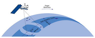
Special features of the AATSR instrument included its use of a conical scan to give a dual-view of Earth's surface, on-board calibration targets and use of mechanical coolers to maintain the thermal environment necessary for optimal operation of the infrared detectors.
The SST is one of the most stable of several key geophysical variables which, when determined globally, contribute to the characterisation of the state of Earth's climate system.
The precise measurement of small changes in SST provides an indication of quite significant changes in ocean/atmosphere heat transfer rates, especially in the tropics. It is also known that small amplitude anomalies occurring in specific areas are sometimes associated with massive atmospheric perturbations, leading to widespread and damaging changes in the global weather system. For example, the El Nino anomaly in the tropical East Pacific is associated with a reversal of the atmospheric Walker Circulation. This in turn creates widespread perturbations to the global weather system.
The exact causal relationships between such phenomena are not fully understood but a significant El Nino event can evolve from an SST anomaly of 2–3 K, and therefore the ability to detect, for example, a 10% change in the anomaly field require measurements of the accuracy provided by the series of (A)ATSR instruments.
The principle of removing atmospheric effects in measurements by viewing the sea surface from two angles (views) is the basis of the family of (A)ATSR instruments. The SST objectives were met through the use of thermal infrared channels (centred on 1.6, 3.7, 10.85 and 12 µm), identical to those on ATSR-1 and ATSR-2. Atmospheric modelling for ERS-1 showed that ATSR, with its thermal infrared channels and two-angle viewing geometry, could achieve a global accuracy in SST better than 0.5 K.
As with the AATSR thermal infrared channels, the measurement philosophy with respect to the visible channels was to develop and exploit a capability for making accurate quantitative measurements of radiation from the Earth's surface, using an on-board calibration system for radiometric accuracy, also using a two-angle viewing technique to obtain accurate atmospheric corrections.

The two most important visible channels were centred on 0.865 and 0.67 µm, and are able to provide measurements of Vegetation Index in the same way as the NOAA AVHRR instrument. AATSR was capable of making global measurements with 1 km x 1 km resolution at nadir. An additional visible channel at 0.55 µm was also incorporated, which can indicate the growth stage and health of vegetation from chlorophyll content.
The infrared–visible radiometer included an inclined plane scan mirror, which was rotated continuously in front of a reflecting telescope to provide a conical scan. The cone axis projected downwards and ahead in the along-track direction of the satellite, achieving scanning across the satellite track in two regions.
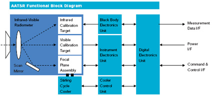
The Focal Plane Assembly (FPA) was equipped with a number of oversized detectors, one per channel. A pair of Stirling Cycle Coolers, controlled by the Cooler Control Unit were used to cool the detectors to 80 K. Two blackbody infrared calibration targets controlled by the Black Body Electronics Unit and a diffuse reflector visible calibration target were viewed between the nadir and along-track scans.
The electrical signals from the FPA were conditioned by preamplifiers, which delivered the signals to the Instrument Electronics Unit for further processing. The Digital Electronics Unit (DEU) performed the data formatting, command and control functions.
Technical Characteristics
- Operation: Continuously over full orbit
- Data Rate: 625 kb/s
- Mass: 101 kg
- Power: 100W
- Swath Width: 500 km
- SST Accuracy: better than 0.5K
- Expected Accuracy:
- Sea surface temperature: <0.5K over 0.5° x 0.5° (lat/long) area with 80% cloud cover
- Land surface temperature: 0.1 K (relative)
- Spatial Resolution:
- IR ocean channels: 1 km x 1 km
- Visible land channels: 1 km x 1 km
- Radiometric Resolution: 0.1 K
- Waveband:
- VIS - NIR: 0.555, 0.659, 0.865 µm
- SWIR: 1.6 µm
- MWIR: 3.7 µm
- TIR: 10.85, 12 µm
Sensor Modes
AATSR had a single operational mode, MEASUREMENT mode, for nominal routine operations. When in MEASUREMENT mode, science data were generated and distributed. For most of the time, AATSR was in MEASUREMENT mode and required no commanding from ground for specific observations.
Whilst in MEASUREMENT mode, the main interruptions to the flow of science data were due to:
- Outgassings: These events encompassed the periods where the cooler drive amplitudes were commanded to zero to allow the infrared focal plane assembly to warm up to ambient temperatures for decontamination. AATSR remained in MEASUREMENT mode, but the data it recorded were compromised.
- Blackbody Crossovers: These events encompassed the periods where the hot and cold blackbodies, components of the on board calibration system, switched roles to determine / test if there were any gross calibration errors. AATSR remained in MEASUREMENT mode to allow Level 0 data generation for analysis, but the data it recorded were compromised.
Several support modes were used to achieve or maintain full instrument operational conditions:
- LAUNCH
- OFF
- RESET / WAIT
- STANDBY
- STANDBY / REFUSE
- HEATER
In HEATER mode, the Instrument Control Unit (ICU) was running, and monitoring and controlling the instrument. All instrument subsystems were running and at operational temperatures, only the generation of measurement (science) data was paused. AATSR was commanded to HEATER mode during Envisat Orbit Control Manoeuvres.
AATSR Instrument Operations
Routine and anomalous activities affected the operations of the AATSR instrument throughout the Envisat mission lifetime.
Housekeeping Activities
Two routine housekeeping activities affected AATSR data quality during the Envisat mission. The Outgassings and Blackbody Crossover Tests table below lists the periods during which these activities were conducted. For full information on these activities, download the AATSR Events Report.
Download the table of outgassing periods.
| Start time | End time | Orbit start | Orbit end |
|---|---|---|---|
| 30/04/2002 | 02/05/2002 | (not known) | (not known) |
| 21/04/2004 07:42 | 23/04/2004 08:17 | 11197 | 11226 |
| 17/05/2005 07:47 | 19/05/2005 08:24 | 16794 | 16823 |
| 26/06/2006 07:20 | 28/06/2006 08:10 | 22591 | 22620 |
| 13/11/2007 07:53 | 15/11/2007 08:30 | 29820 | 29849 |
| 21/04/2009 07:53 | 23/04/2009 08:31 | 37335 | 37364 |
| 26/05/2010 08:18 | 28/05/2010 08:55 | 43061 | 43090 |
| 25/05/2011 10:46 | 27/05/2011 11:12 | 48284 | 48313 |
Mission Events
Download the list of all major events for the AATSR instrument during the Envisat mission lifetime from 1 March 2002 - 8 April 2012.
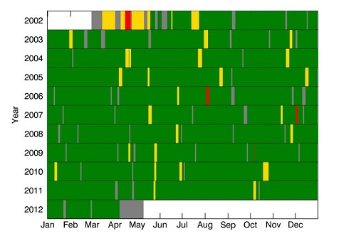
Events History - Data Availability

Key:
- Grey = No data generated (AATSR not in MEASUREMENT mode)
- Green = Good quality data
- Amber = Data generated but of lower quality
- Red = No data generated due to AATSR anomaly
This summary of AATSR data availability and quality for the mission is based on the AATSR modes of operation and the instrument event history.
AATSR measurement data were available for more than 95% of the mission, excluding the main commissioning phase up to 23 July 2002.
Reference
[1] Smith. D. L. (2012) Envisat AATSR Instrument Performance - End of Mission Report, PO-RP-RAL-AT-0621, Issue 1.0.
Instrument Modes

Key:
- Grey = all units off
- Orange = AATSR in STANDBY or WAIT
- Amber = AATSR in HEATER or transition to HEATER
- Green = AATSR in MEASUREMENT mode
- Cyan = outgassing while AATSR in MEASUREMENT mode
- Blue = blackbody cross-over while AATSR in MEASUREMENT mode
- Red = AATSR in STANDBY/REFUSE or WAIT due to instrument anomaly
Note that the days on which the instrument was in a certain mode are indicated and not necessarily the duration. For example, to cover an OCM, AATSR will have been in HEATER mode for only a few hours and returned to MEASUREMENT at the end of the manoeuvre.
In the event of a platform anomaly AATSR was commanded to OFF or STANDBY by platform command.
In the event of an instrument anomaly, AATSR would enter STANDBY/REFUSE autonomously or be commanded to RESET/WAIT by platform command.
Reference
[1] Smith. D. L. (2012) Envisat AATSR Instrument Performance – End of Mission Report, PO-RP-RAL-AT-0621, Issue 1.0.
Non-Nominal Data Periods
AATSR data quality was affected on the following dates.
For full information on the events listed below, download the AATSR Performance Report.
| Start Time | End Time | Orbit Start | Orbit End |
|---|---|---|---|
| 28/10/2003 06:26 | 28/10/2003 13:10 | 08677 | 08681 |
| Start Time | End Time | AATSR product name orbit start | AATSR product name orbit end |
|---|---|---|---|
| 20/05/2002 09:52 | 22/07/2002 23:42 | 01149 | 02058 |
| Start Time | End Time | Orbit Start | Orbit End |
|---|---|---|---|
| 27/10/2010 18:55 | 02/11/2010 10:25 | 45272 | 45353 |
AATSR Resources
- AATSR Instrument paper
- AATSR Product Handbook
- The Product Handbook contains much useful information; however user should be aware that the Envisat product format and Level 2 processing User Documentation for (A)ATSR 4th Reprocessing Level 1B Products details have now been superseded. For more details on the last updates check also the User Documentation for (A)ATSR 4th Reprocessing Level 1B Products.
- AATSR Events Report
- AATSR Performance Report throughout the whole Envisat mission
- AATSR Products Specifications
- AATSR - Frequently Asked Questions (FAQ) Document
- ATSR Exploitation Board
- Climate Change Initiative - SST
- Climate Change Initiative - LST