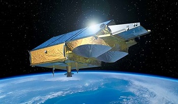
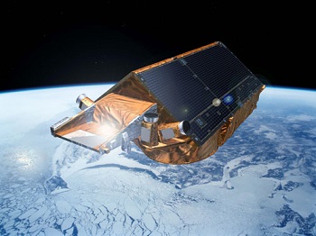
- CryoSat
- Mission
- CryoSat Overview
CryoSat Overview
Mission Background
CryoSat's radar altimeter is based on heritage from existing instruments, but with several major enhancements designed to improve measurements of icy surfaces. Because of its operations in SAR and Interferometric modes, the altimeter is called SIRAL (SAR Interferometric Radar Altimeter). CryoSat orbits at an unusually high inclination, reaching latitudes of 88° North and South.
CryoSat determines the thickness of floating sea ice by measuring the freeboard of ice floes; that is the height by which the ice extends above the water surface. This technique has been demonstrated with the ERS-1 radar altimeter, but this instrument, as with all conventional radar altimeters, is hampered by its relatively low spatial resolution of about 5 km. CryoSat achieves improved spatial resolution of 250 m in the along-track direction using the Synthetic Aperture technique.
The first returning energy in the radar echo comes from the part of the Earth's surface closest to the satellite. Over sea ice (and ocean) this point is directly below the satellite, but on sloping surfaces, such as those found around the edges of ice sheets, this nearest point can be anywhere. CryoSat is able to pin down the location of the echo in the fore- and aft-direction by using its SAR capability, but to resolve left and right an additional feature is needed. Over these sloping surfaces, CryoSat operates in SAR-Interferometry mode, which provides the key measurements of the angle of arrival and thus the pin-pointed source of the echo.
CryoSat was the third Earth Explorer mission to be launched. The Earth Explorers are specialised missions dedicated to observing different aspects of the planet and our environment. A secondary aim of the programme is to understand how these aspects interact with one another.
CryoSat is the first ESA mission dedicated to study the Earth's cryosphere, but during the course of the mission applications for oceanography have been discovered.
This satellite replaced the original CryoSat which was lost due to a launch failure in October 2005.
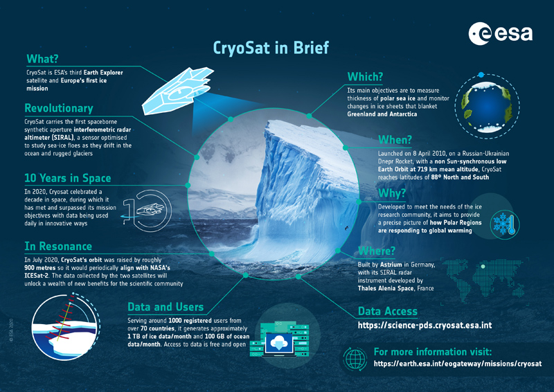
CryoSat Infographic
To mark the 10th anniversary of CryoSat in 2020, an infographic was produced to highlight the mission and its many achievements:
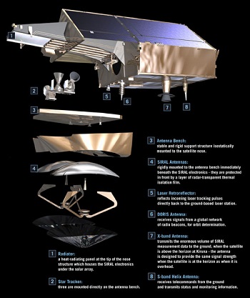
Satellite Design
CryoSat is a satellite with a single primary mission objective – therefore, the selection of its orbit and basic characteristics has been entirely driven by the scientific requirements.
Unlike most remote sensing satellites, CryoSat's orbit is not Sun-synchronous, but will go through frequent eclipse phases. This has presented some challenges in the satellite design; all parts will at some time be exposed to the full heating power of the Sun, while at other times parts of the satellite will be in permanent shadow for weeks on end.
CryoSat does not have any deployable solar panels; in fact the satellite has no moving parts at all, except for some valves in the propulsion system. This has enabled a very significant cost saving, but does pose some problems for the provision of adequate solar power in CryoSat's unusual orbit. The solar panels are fixed to the satellite body, forming a 'roof' at a carefully optimised angle, which provides adequate power under all orbital conditions and still fits within the launch vehicle.
The other area that receives particular attention has been the mounting of the two SIRAL antennas. The baseline on which the SIRAL antennas were mounted has to be completely stable and has to ensure minimal thermal expansion. Any distortion will lead to errors in the assumed location of the echo and hence the elevation of the surface of the ice. The challenge has been met by designing the structure to be intrinsically stable and providing auxiliary attitude measurement sensors, in the form of star trackers, mounted directly onto the antenna bench structure.
The satellite is 4.6 m x 2.34 m x 2.2 m in dimension and has a mass of 725 kg.
Mission Operations
CryoSat flies in a non sun-synchronous low Earth Orbit at 92° inclination and 717 km mean altitude. The satellite has a 369 day repeat cycle (with a 30 day sub-cycle).
The mission has a single ground station at Kiruna in Sweden, which is responsible for payload data processing.
The flight operations are conducted at ESOC (European Space Operations Centre) in Germany.
Data is locally archived with precision processing one month after the delivery of precision orbits from the DORIS ground segment (under CNES responsibility).
User services and mission planning are coordinated at ESRIN, in Italy.
Track the CryoSat mission in orbit in real time using the ESTRACKnow tool.
| Power | 2x GaAs body-mounted solar arrays, with 800 W each at normal solar incidence. 78 Ah Li-ion battery. |
| TM-band | X-band data downlink: 100 Mbps at 8.100 GHz S-band TTC link: 2 kbps uplink, 16 kbps downlink |
| Data Volume | 1 internally redundant Solid-State Recorder, total capacity 256 Gbits |
Ground Segment
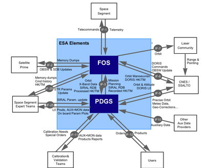
The CryoSat ground segment is currently organised around a single ESA ground station, located in Kiruna in northern Sweden. This is where contact is established with the satellite, for about 10 minutes 11 times per day, during which commands are sent to the satellite, and data downloaded over an X-band microwave link.
Mission planning, however, is performed in ESA-ESRIN for what concerns the payload part (mainly the instrument activity planning) and in ESA-ESOC for what concerns the platform part (mainly orbit maintenance through manoeuvres). The detail plan is uploaded weekly to the satellite from Kiruna-Salmijarvi.
It is worth noting that the CryoSat instrument activity is mostly repetitive, and is based on ground topology (ice boundaries evolving through the year) with a few specific user demands for Near Real Time applications, therefore it is subject to periodic modifications which follow the seasonal cycle.
The large amount of data received from the payload, and in particular from the altimeter, is processed at Kiruna-Esrange. Data products at Level-1b (radar echoes geo-located and corrected for instrument features) and Level-2 (ground elevation and ice freeboard, corrected for atmospheric and geo-physical effects) are produced by ESA systematically, based on the repetitive data acquisition planned above. There is no 'on-demand' data processing in the routine data production; however, provision is made for troubleshooting needs.
All external auxiliary data needed for the data processing, and in particular the Precise Orbit data is received from the SSALTO centre operated by CNES in Toulouse, with one exception - dynamic sea-ice concentration which is received from UCL in London.
Data are routinely distributed to users via the internet. Use of high-speed infrastructure and network services are also used to the maximum extent feasible.
Related Links
- CryoSat Mission and Data description document
- CryoSat on the eoPortal*
- CryoSat Operational Polar Monitoring*
- CPOM*
- Earth Observation Principal Investigators (EOPI) community
- ICESat Mission*
- International DORIS Service (IDS)*
- NOAA CryoSat IGDR*
- National Snow and Ice Data Center (NSIDC)*
- Sea-ice data products (AWI)*
*The information provided is sourced and updated by external entities. For further details, please consult our Terms and Conditions page.
Social and multimedia links
- Follow us on X (formerly known as Twitter)
- CryoSat on the eoPortal
- Arctic Campaign Blog
- CryoSat iPhone app
- CryoSat iPad app
- CryoSat app for Android