- All Categories (17)
- Data (2)
- News (11)
- Missions (1)
- Tools (1)
- Documents (2)
News - Infographics
Explore sample data products from Third Party Missions
ESA’s Third Party Missions programme consists of over 50 satellite missions from commercial and public organisations worldwide.
Data - Sample Data (Open)
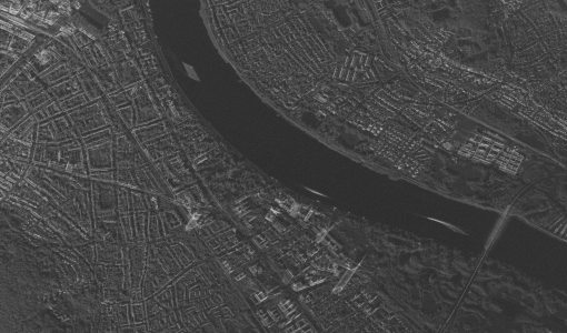
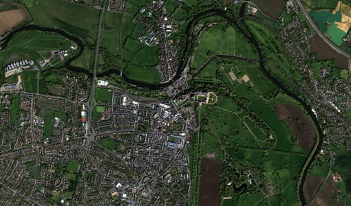
Vision-1 sample data
Download free Vision-1 sample datasets to preview products available for this mission.
News - Data Release news
Sample data products from ESA’s Third Party Missions
Samples of data products from a range of Third Party Missions are now available to download, offering a preview of what these missions provide.
News - Success Stories
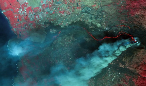
Commercial and international data for fire monitoring
As climate change sparks a surge in the frequency and intensity of wildfires, satellite data disseminated through ESA’s Third Party Missions (TPM) programme are helping scientists to track and investigate these potentially damaging natural events.
News - Thematic area articles
How satellite data empower sustainable urban growth
Earth observation is a vital tool for facilitating the sustainable development of the world's cities, helping to ensure that urban centres keep spurring collaboration, innovation and opportunity as they continue to expand.
News - General News
International collaboration: Summarising ESA’s Third Party Missions
ESA’s Third Party Missions programme consists of more than 50 missions from around the world. Learn more about the Third Party Missions in this video.
News - Thematic area articles
How satellite data help to shape society
Data from ESA’s Earth observation archives are improving understanding of the interactions between human activities and the environment, helping to power green economic development and boosting prosperity in Europe and beyond.
News - Infographics
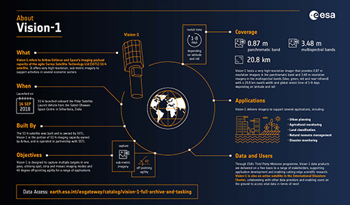
An overview of the very high-resolution Vision-1 satellite
Learn about Vision-1, which joined ESA's Third Party Missions programme in May, in our new infographic.
News - Events and Proceedings
VHR Data Quality in the limelight
In recent years, the satellite landscape has steadily expanded with a variety of very high resolution (VHR) commercial satellites, also emerging from new space providers. A result of this growth is an increased need to address data quality assurance.
Document - General Reference

Third Party Missions Brochure
This brochure summarises ESA's Third Party Missions programme, providing a timeline and examples of content related to some of the missions.
News - Data Release news
Vision-1 data now open to users
In the framework of the Third Party Missions programme, ESA is offering, for scientific research and application development, access to archive and new tasking data from the Vision-1 mission upon submission and acceptance of a project proposal.
News - Success Stories
Vision-1 to enable cutting-edge science and spur innovation
Vision-1 – which is the result of a collaboration between Airbus Defence and Space and Surrey Satellite Technology Ltd. (SSTL) – provides sub-metric imagery to support activities across many industries, including urban planning, agricultural monitoring, land classification, natural resource management and disaster monitoring.
News - Success Stories
New open-source Python library improves rapid mapping services
In emergency services, rapid response is paramount. ICube-SERTIT’s Rapid Mapping Service provides near real-time delivery of geo-information to help emergency services respond quickly to disasters such as flooding, fires and landslides. A new Python open-source library, called EOReader, speeds up this mapping response by enabling the easy opening of imagery from multiple satellite sensors, both optical and synthetic aperture radar (SAR).
Data - Project Proposal (Restrained)
Vision-1 full archive and tasking
Vision-1 provides very high resolution optical products, with 87cm resolution in Panchromatic mode and 3.48m in Multispectral Mode. Products are in DIMAP format; the image is in GeoTiff format with 16 bit encoding; the applied geographical projection is WGS84 UTM. Spectral band combination options: Panchromatic (PAN): includes data contained within a single high resolution black and white band, with product pixel size of 0.87m Multispectral (MS4): includes four multispectral (colour) bands: Blue, Green, Red and Near Infrared. The product pixel size is 3.48m Bundle (BUN): provides both the 4-band multispectral, and the panchromatic data from the same acquisition in a single, non-merged product. Data is provided as 16-bit GeoTiffs with pixel sizes of 3.48m and 0.87m for MS and PAN data respectively Pansharpened (PSH): single higher resolution 0.87 colour product obtained by the combination of the visual coloured information of the multispectral data with the details provided in the panchromatic data. Two different geometric processing levels are: Projected (level 2): The product is mapped onto the Earth cartographic system using a standard reference datum and projection system at a constant terrestrial altitude, relative to the reference ellipsoid. By default, the map projection system is WGS84/UTM. The image is georeferenced without the application of a Digital Elevation Model (DEM) and supplied with the RPC model file. Pansharpened are not available as projected product Standard Ortho (level 3): georeferenced image in Earth geometry, including the application of a Airbus World DEM for Ortho and GCPs (using Airbus Intelligence One Atlas BaseMap as reference). The orthorectification procedure eliminates the perspective effect on the ground (excluding buildings) to restore the geometry of a vertical shot. Only the basic radiometric processing is available providing the radiance value. As per ESA policy, very high-resolution imagery of conflict areas cannot be provided.
Mission - Third Party Missions
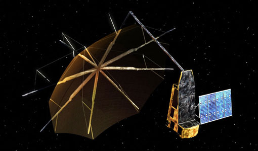
Vision-1
Launched on 16 September 2018, Vision-1 offers orthorectified products with resolution up to 87 cm in panchromatic mode and 3.48 in multispectral mode as standard.
Tools - Analysis
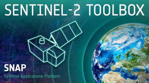
Sentinel-2 Toolbox
The Toolbox consists of a rich set of visualisation, analysis and processing tools for the exploitation of optical high-resolution products including the Sentinel-2 MSI sensor.