- Learn & Discover
- SAR synergy data for maritime ...
SAR synergy data for maritime surveillance
26 Jul 2022
Poaching of fish stock in protected areas puts marine biodiversity and habitats at risk. With the aim of safeguarding our oceans, a recent study uses a synergy of synthetic aperture radar (SAR) images to improve maritime surveillance.
In a world threatened by environmental hazards such as waste dumping and oil spills, as well as illegal fishing in marine protected areas, surveillance of the sea is of increasing importance. Maritime Situational Awareness (MSA) involves understanding the activities in our oceans and seas.
To enforce MSA surveillance, the International Maritime Organisation mandates that all passenger ships irrespective of size, and cargo ships of 500 tonnes or more, carry an automatic identification system (AIS) to track their routes. Furthermore, fishing vessels of lengths greater than 15 metres are required to have AIS transponders in EU waters.
Many ships do not comply to this mandate, however, engaging in unlawful fishing practices, which can damage marine habitats and their population diversity.
A research group at the Department of Industrial Engineering at the University of Naples Federico II utilised SAR images from three different satellite missions, to improve the tracking of vessels, even those without AIS transponders.
By leveraging multi-mission SAR data ranging from L-band, X-band to C-band, the scattering mechanisms of complex targets, such as ships, were analysed and characterised.

Thanks to its Third Party Mission Programme (TPM), ESA facilitates access to data from the SAOCOM and COSMO-SkyMed missions. These data are available free-of-charge via Earthnet, a single programme offering commercial and institutional mission data (which are not owned by ESA) to the science community.
The COastal Area monitoring with SAR data and multimission/multifrequency Techniques (COAST) project, supported by the Italian Space Agency, aims at providing accurate characterisation of visible maritime vessels through the synergetic exploitation of multifrequency data from COSMO-SkyMed and SAOCOM, as well as Copernicus Sentinel-1.
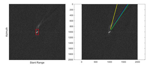
As a ship moves in the sea, it generates waves, eddies and foam to form a trail on the water surface, known as the wake.
Roberto Del Prete, researcher from the University of Naples, says, “The wake can be visible in SAR images and exploited for not only ship detection, but also to estimate the vessel’s velocity and route.
“While SAR data have previously been used for maritime situational awareness, this study is unique as it uses a synergy of multimission SAR data to detect ship wakes. We wanted to see what happened when we used SAR data from more than one mission.”
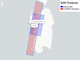
The COAST project covered four study areas, which are protected marine areas or marine areas affected by unlawful activities, namely the Isole Egadi Marine Protected Area, north Sardinia, the Alboran Sea and the South Adriatic Sea.
Data products from the three different missions were matched on a spatio-temporal basis in the various study areas. Of primary interest were the sea areas where the products overlapped.
A cascade approach was employed, which used a sub-look analysis to screen the SAR images. The analysis removed false alarms detected before the screening and made it easier to identify both visible ships, and those that were not carrying AIS transponders.
This pre-selection and discrimination approach was applied to multi-frequency data acquired from the different missions, within a short time lag of less than 15 minutes.
Identification was also achieved by studying wakes in multi-frequency SAR images, and also by the 3D reconstruction of ships by means of SAR tomographic techniques.

The researchers corroborated their results by purchasing AIS data for the study areas from ExactEarth. In this way the study experimentally verified the advantages of using multimission and multifrequency SAR data for the monitoring of human activity at sea. They also developed a wake-based ship identification method, which allows discrimination between wake and look alike features.
Improved maritime surveillance using these methods, may help prevent illegal fishing and trafficking in the future.