- News
- Remote sensing scientists rais...
Remote sensing scientists raise alarm for African savannah
04 Oct 2022
Researchers have used high resolution WorldView-3 imagery to map vegetation cover in the Greater Maasai Mara savannah, a global hotspot for biodiversity in Kenya.
Their analysis revealed striking changes to wooded areas that could have wide-spread impacts on ecosystems in the region.
Species-rich savannahs, where trees, shrubs and grasses co-exist, cover around twenty percent of Earth’s land surface.
Africa’s savannahs are experiencing biodiversity loss as key ecosystems, such as the Greater Maasai Mara (“the Mara”) savannah in Kenya, are threatened.
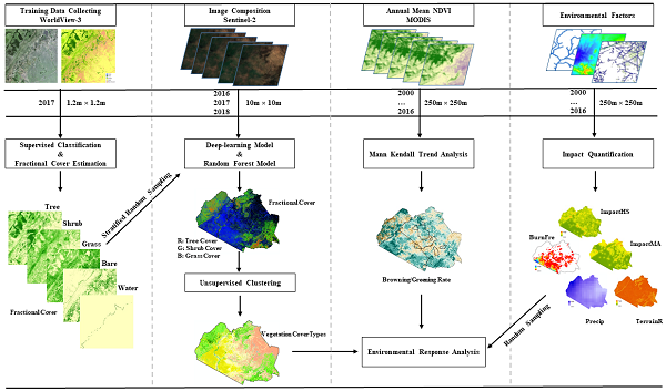
The Centre for Biodiversity Dynamics in a Changing World (BIOCHANGE) group, at Aarhus University in Denmark, derived high resolution vegetation maps of the region by integrating data from WorldView-3 and Copernicus Sentinel-2 using a deep-learning workflow [1].
An ESA Third Party Mission, WorldView-3 is an environment-monitoring satellite owned by US space technology firm Maxar Technologies, and locally tasked in Europe by German data supplier European Space Imaging.
The teams’ results show that woody areas in the Mara are becoming more dense, posing risks to its high-quality grass cover and threatening megafauna, such as seasonally migrating ungulates.
Wang Li, lead researcher for the project in the BIOCHANGE group says, “Savannahs are a unique ecosystem composed of a mixture of trees, shrubs, and grass, where a diversity of wildlife exists alongside humans. The habitat quality can only be maintained if this mixture of different land types remains intact.
“For example, giraffe often feed on leaves of certain tall trees or shrubs, while other faunae choose grass or shorter shrubs. We selected to study the Greater Maasai Mara savannah as it is one of Earth’s biodiversity hotspots, with unique wildlife migration and very representative of savannah habitats.”
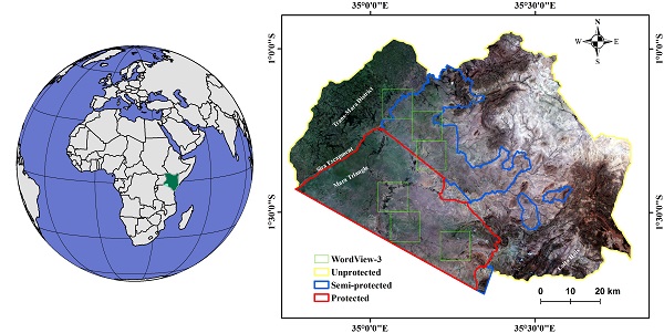
The Mara ecosystem is in south-western Kenya and borders to the north of Tanzania. The research delivered the first comprehensive vegetation map of the region at a high spatial resolution of 10 metres.
The map was derived in a two-step process, integrating data from high-resolution WorldView-3 images and Copernicus Sentinel-2 images using a deep-learning approach.
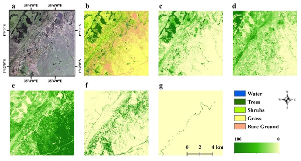
In six regions of interest within the Mara, the team used very high resolution WorldView-3 imagery (1.2 metre pixel size) to estimate fractional covers of five elementary land cover types (LCTs) – tree, shrub, grass, bare soil, water – in 10 metre pixels.
Li adds, “The WorldView-3 images are so high resolution that it was easy for us to see the land cover and classify it into these five basic LCTs, with a high level of confidence. We can even see individual crowns in the shrubs.
“In our previous work - using Landsat data - we couldn’t easily differentiate between the mixture of land cover types, especially shrub and wood cover, which have similar reflectance.”
Together with field collected photos, the team used the WorldView-3 data to train the model to classify land cover types throughout the region – using it as so-called “ground truth data”.
The ground truth data were extrapolated to cover the entire Mara region, using the broad coverage of data delivered in 2017, by Sentinel-2 of the European Union’s Copernicus Programme.
To identify if a given LCT is impacted by vegetation degradation or densification, the information derived from the model for 2017 was linked to long time-series annual MODIS NDVI data for the preceding 17 years, which helps show if areas are becoming greener.
A key finding from the study was an increase in the greenness of LCTs with woody dominance, suggesting there is ongoing woody densification happening across the Mara.
The observed woody densification also seems to be partially related to precipitation dynamics, which merits further investigation. Vegetation declines within the non-woody LCTs in the semi- and unprotected lands, were also observed, likely related to high levels of livestock grazing and conversion of savannah to cropland.
As the international community advances its efforts to curb biodiversity losses, remote sensing will continue to play a vital role - as any change in the mixture of land types in savannahs poses a threat to wildlife.
Find out more about WorldView-3 archive and data.
References:
[1] W. Li et al. “Deep-learning based high-resolution mapping shows woody vegetation densification in greater Maasai Mara ecosystem.” Remote Sensing of Environment 247 (2020) 111953.