- News
- High-resolution optical images...
High-resolution optical images improve geological mapping in remote geothermal areas
29 Mar 2022
A group of researchers from the Centro de Geociencias (CGEO) at the National Autonomous University of Mexico (UNAM), in collaboration with the Istituto di Geologia Ambientale e Geoingenieria (IGAG) of the Italian National Research Centre (CNR), carried out a study on integrating remote sensing analysis with geological and geophysical fieldwork, over the Cerro Domuyo mountain in Patagonia—this led to the use of GeoEye-1 data, which proved to be invaluable, highly improving their understanding of the magmatic and tectonic evolution of this geothermal volcanic area.
Cerro Domuyo is the highest mountain in Patagonia. Since the 1980s, a geothermal reservoir was established on its western slope due to the presence of thermal springs with boiling fluids, silicic domes and pyroclastic deposits.
A geochemical survey estimated a temperature of 220°C for the fluid reservoir and a thermal energy release of ~1.1 Gigawatts (GW)—one of the world's largest advective heat flux from a continental volcanic centre.
As a consequence of the drive towards a decarbonised and lower emissions future, forthcoming low-emission energy systems will require new, green-clean energy sources. Geothermal energy is the heat that comes from Earth’s sub-surface and is stored in the rocks and fluids beneath its crust. It can be found as far down as Earth's hot molten rock—magma. Geothermal sources are a local phenomenon, as few sit on underground rivers of steaming hot water. Additionally, most places are remote, and exploration surveys could be risky.
Few studies existed about the geology of this volcanic area, and well-constrained data, spanning an extensive area, were needed to address questions on the distribution of the permeability in the geothermal system and its relationship with the magmatic heat source, the local stratigraphy, and the tectonic and volcano-tectonic structures.
However, unconsolidated pyroclastic rocks covering the volcanic mountain slopes, conditions in the high-relief terrain, climate conditions and difficulties in finding accessible roads, made exploration surveys challenging to carry out.
To tackle these problems, integrating remote sensing analysis with geological and geophysical fieldwork was an effective approach, for better understanding the magmatic and tectonic evolution of the geothermal volcanic area.
The final aim of this research was to reconstruct the relationship among the stratigraphy, structures and the hydrothermal system of the Domuyo western flank, enabling a better understanding of the structural architecture of the geothermal area, which is valuable for geothermal exploration of the volcano. (The results of this study are now available in Argelia-Silva et al., (2021).)
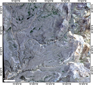
Thanks to ESA’s Third Party Missions, (project Nr 34496), the research team gained access to GeoEye-1 data, which provide up to 0.4 m panchromatic resolution and 1.65 m multispectral resolution, which is currently one of the most advanced image systems ever used in commercial remote sensing (another example of a VHR sensor that can deliver such data is Pléiades Neo, which will be offered through the Third Party Missions programme soon).
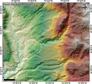
GeoEye-1 optical images with a resolution from 0.4 to 0.5 m allowed generation of a highly accurate Digital Elevation Model (DEM). This DEM, coupled with orthorectified satellite images, generated different maps to guide the fieldwork campaigns at the 1:10,000 scale.
The advantage of having high-resolution maps was in identifying specific targets to survey before the fieldwork campaigns started. A map with the main faults and the fracture systems was created in an early stage. Later on, it was verified and integrated with the stratigraphic and structural fieldwork.
Digital Elevation Models represent the main input data of topographic corrections on gravimetric surveys. These provide information about the height of the surface. Therefore, with the higher resolution of the DEM, more accurate gravity anomaly data can be obtained.
The high-resolution elevation model was used in the generation of the electrical-resistivity model of the region, to account for major topographic features and interpolate on the defined grid discretisation. Therefore, it was possible to obtain a more accurate magneto-telluric model with a high topographic resolution, as there was a better iterative process.
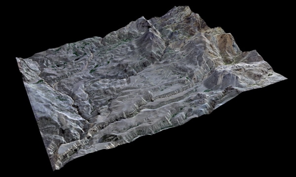
The innovative nature of this research relied mainly upon the multidisciplinary methodology that was applied to the geological and geophysical study. Combining high-resolution, optical panchromatic, multispectral satellite data with medium-resolution remote sensing was a supportive tool to identify the geological structures, lithology and hydrothermal alterations, which also improved geophysical modelling.
The outcomes provide new detailed insight into the structural architecture of the Domuyo volcano and geothermal field.
New stratigraphic and structural data are now available for the geothermal area. Their research represents a fundamental step for defining a volcano-tectonic model, which is a helpful guide in the geothermal exploration of the site.
Argelia Silva Fragoso, Head Researcher, affirms, “The GeoEye-1 data were our second eyes. We were able to make observations of places that, perhaps, we would never have reached on foot. The high-resolution images allowed us to return to the field without the need to be physically in it."
References
Chiodini, G., Liccioli, C., Vaselli, O., Calabrese, S., Tassi, F., Caliro, S., D'Alessandro, W., 2014. The Domuyo volcanic system, An enormous geothermal resource in Argentine Patagonia. J. Volcanol. Geotherm. Res. 274, 71–77.