- News & Events
- Countdown to Biomass: Earth ob...
Countdown to Biomass: Earth observation experts await game-changing data
25 Feb 2025
As preparations for the launch of Biomass continue, the scientific community is eagerly anticipating the unprecedented insights into forests that the breakthrough mission promises to deliver.
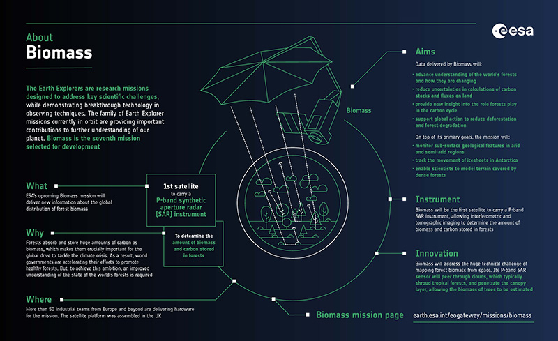
Biomass, ESA’s seventh Earth Explorer mission, is expected to launch into space aboard a Vega-C rocket from Europe’s Spaceport in French Guiana in April. Years in the making, it is the first Earth observing mission to host a radar sensor capable of measuring above ground biomass and tree heights across multiple types of forest.
Reducing uncertainties
Forests store huge amounts of carbon and, consequently, play a crucial role in the carbon cycle and climate change.
However, the lack of wall-to-wall above ground biomass and forest height data available on a wide geographical scale means that understanding of the state of the world’s forests, as well as their contribution and impact on the carbon cycle and climate, is limited. Biomass is expected to close this knowledge gap.
Scientists will use data from the mission to reduce uncertainties in calculations of carbon stocks and fluxes on land, including carbon fluxes associated with deforestation and forest regrowth.
Breakthrough P-band radar
Biomass is the first satellite to host a Synthetic Aperture Radar (SAR) sensor that operates in the P-band frequency range.
What is P-band SAR?
P-band SAR is a type of radar imaging system that operates in the long-wave P-band frequency range, with a wavelength of 70 cm. P-band signals penetrate deep within the forest canopy to detect large branches and tree trunks.
This technology presents many benefits for the monitoring of forest biomass and forest height when compared to shorter-wave SAR sensors, such as C-band, L-band and X-band.
P-band radiation interacts with the parts of the tree where most of the biomass is stored, whereas shorter wavelength SAR radiation interacts with the outer layers of the forest canopy, such as leaves or small branches.
In addition, P-band SAR allows for high temporal coherence between acquisitions collected at intervals of several weeks, which is important for the estimation of forest height and forest structure based on data collected at different timepoints.
Innovative trio of SAR techniques
Biomass will transform understanding of forests by using three complementary remote sensing technologies: polarimetry (PolSAR), polarimetric interferometry (Pol-InSAR), and tomographic SAR (TomoSAR).
What are the functions of PolSAR, Pol-InSAR and TomoSAR?
- PolSAR involves emitting SAR radiation at different polarisations, with the contrasting reflections helping to distinguish between features on the ground
- Pol-InSAR combines two or more PolSAR images taken at different angles, allowing scientists to precisely estimate the heights of trees and terrain
- TomoSAR draws on multiple SAR images acquired at different time points and at different angles to generate a 3D model of an area of interest
The experimental TomoSAR phase will take place in the first 18 months of operations, following the satellite’s commissioning. The remainder of the five-year mission will be dedicated to the collection of repeated SAR data for interferometric analyses.
Scientists will combine PolSAR, Pol-InSAR and TomoSAR techniques to produce estimates of above ground biomass and forest height. Both products will have a spatial resolution of 200 metres.
In addition, Biomass observations will be used to create a severe forest disturbance product, which maps areas of deforestation. This product will have a spatial resolution of 50 metres.
Key to the success of Biomass will be a series of calibration/validation (cal/val) campaigns designed to ensure the accuracy and reliability of its data products. Preparations are already underway for these activities, with the opening of a dedicated announcement of opportunity for scientists to participate.
Unprecedented data, unforeseen opportunities
To gear up for the availability of Biomass data, scientists have been advancing the development of new quantitative methods to exploit Biomass observations in models of climate change and the carbon cycle. This is key to the mission’s objective of reducing uncertainties of carbon stocks and fluxes in the terrestrial biosphere.
Beyond forest monitoring, the capabilities of Biomass can also be applied to many other domains, including sub-surface imaging in arid environments, observing the internal structure and velocity of ice sheets, the generation of digital terrain models in areas covered by dense vegetation, and observing the ionosphere.
There are likely to be many other applications for Biomass, which will only become apparent when the scientific community begins to unlock the potential of its data.