
Featured
About SkySat
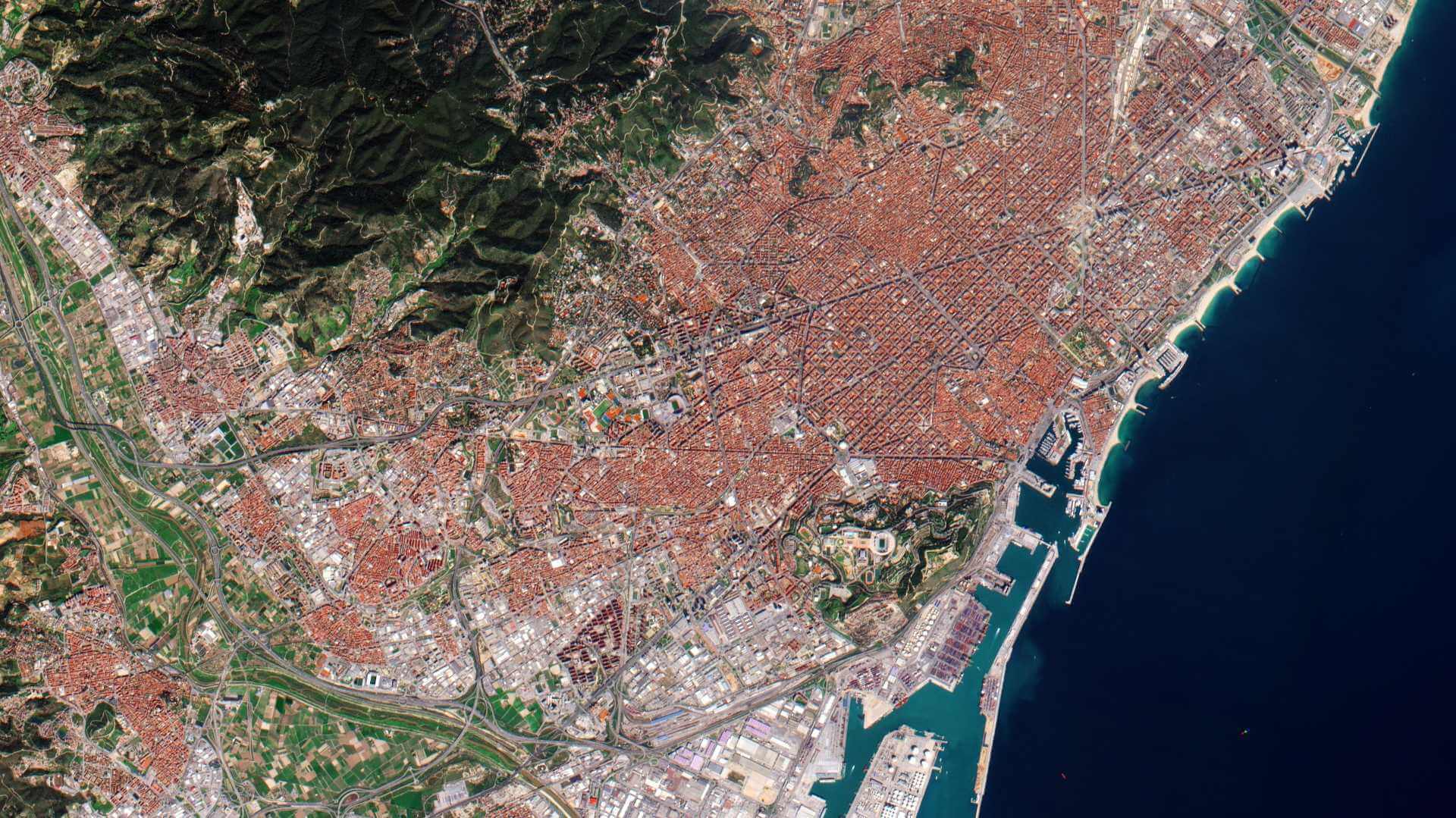
SkySat is a constellation of 21 high-resolution Earth imaging satellites owned and operated by the commercial company Planet Labs. SkySat-1 was launched in 2013 and a launch programme has followed.
The first two SkySat satellites (SkySat-1 and SkySat-2) are A and B Generations, the other 19 satellites are modernised C Generation satellites.
Six of the C-Generation SkySat satellites (from SkySat-16 to SkySat-21) were launched into non-sun-synchronous orbits to increase the image cadence between 52 degrees northern and southern latitude up to 6-7 times per day on worldwide average, with a maximum of 12.
| Operator | Planet Labs |
| Date of Launch | SkySat-1: 21/11/23 SkySat-2: 08/07/2014 SkySat-3: 22/09/2016 SkySat-4-7: 16/09/2016 SkySat-8-13: 31/10/2017 SkySat-14-15: 03/12/2018 SkySat-16-18: 13/06/2020 SkySat-19-21: 18/08/2020 |
| Mission Status | Operating nominally |
| Orbit Type | SkySat-1-15: Sun-synchronous SkySat-16-21: inclined, non sun-synchronous |
| Orbit Altitude | SkySat-1-2: 600 km SkySat-3-15: 500 km at launch, lowered to 450 km in early 2020 SkySat-16-18: 400 km |
| Equator Crossing Time | SkySat-1, 3-7, 14-15 : approximately 10:30 a.m. SkySat-2, 8-13: approximately 13:00 p.m. SkySat-16-21: variable |
| Number of Satellites | 21 |
SkySat Objectives
The SkySat constellation collects thousands of square kilometres of imagery. Each satellite is three-axis stabilised and agile enough to slew between different targets of interest.
SkySat Instruments
SkySat Camera
This is a Cassegrain telescope with a focal length of 3.6 m, with three 5.5 megapixel CMOS imaging detectors making up the focal plane and able to collect frame imagery, stereo imagery, and video by day and by night.
In early 2020 the Skysat C-generation orbits were lowered from 500 km to 450 km altitude which, together with various processing evolutions, brought an improvement of the spatial resolution.
| Sensor Type | SkySat Satellites have three CMOS Frame Cameras per satellite with Panchromatic and Multispectral halves, which capture overlapping strips. Each of these strips contain overlapping scenes. |
| Spectral Bands | Blue 450-515 nm Green 515-595 nm Red 605-695 nm NIR 740-900 nm PAN 450-900 nm |
| Ground Resolution after Super-Resolution processing (nadir) | [SkySat-1, SkySat-2] -A/B Generation Panchromatic: 0.86 m Multispectral: 1.0 m [SkySat-3 - SkySat-15] -C Generation Panchromatic: 0.65 m (0.72 m before 30/06/2020) Multispectral: 0.81 m (1.0 m before 30/06/2020) [SkySat-16 - SkySat-21] -C Generation Panchromatic: 0.57 m Multispectral: 0.75 m |
| Ortho Product Pixel Size | 0.50 m |
| Swath Width | 8 km at nadir (SkySat-1-2) 5.9 km at nadir (SkySat-3-15) 5.5 km at nadir (SkySat-16-21) |
| Maximum Image Strip Length | 200 km |
| Revisit Time | Constellation: sub-daily, 6-7 times at worldwide average, 12 times max. Satellite: 4-5 days (Reference altitude 500 km) |
| Image Capture Capacity | 400k km² /day |
SkySat Data
DATA COLLECTIONS
ESA is offering, for scientific research and application development, access to archive and new tasking data from the SkySat mission upon submission and acceptance of a project proposal. These collections are available as part of the Planet imagery offer.
ESA will support as many high-quality and innovative projects as possible within the quota limit available, therefore only a limited amount of products can be made available to each project.
The following data collections are available:
Product Information
| Name | Description | Product Level |
| SkySat Basic Scene Product | The SkySat Basic Scene product includes Analytic and Panchromatic imagery that is uncalibrated and in a raw digital number format. The Basic Scene Product is not radiometrically corrected for atmosphere or for any geometric distortions inherent in the imaging process. It is provided with RPC values for geopositioning. | Level 2B |
| SkySat Visual Ortho Scene | The SkySat Visual Ortho Scene product is orthorectified, pansharpened, and color-corrected (using a color curve) 3-band RGB Imagery. | Level 3B |
| SkySat Pansharpened Multispectral Ortho Scene | The SkySat Pansharpened Multispectral Scene product is orthorectified, pansharpened, and color-corrected (using a color curve) 4-band BGRN Imagery. | Level 3B |
| SkySat Analytic DN Ortho Scene | The SkySat Analytic DN Ortho Scene product is orthorectified, multispectral data from the SkySat constellation. The Analytic DN product is an uncalibrated, digital number imagery product. This product is designed for a wide variety of applications that require imagery with an accurate geolocation and cartographic projection. The product has been processed to remove distortions caused by terrain. It eliminates the perspective effect on the ground (not on buildings), restoring the geometry of a vertical shot. In addition to orthorectification, the imagery has radiometric corrections applied to correct for any sensor artifacts. The initial availability does not include transformation to at-sensor radiance. | Level 3AB |
| SkySat Panchromatic DN Ortho Scene | The SkySat Panchromatic Ortho Scene product is orthorectified, panchromatic data from the SkySat constellation. The Panchromatic DN product is an uncalibrated, digital number imagery product. The Panchromatic product has a finer GSD than the Analytic Product due to NOAA license restrictions, and is useful for visual interpretation as well as pan-sharpening of coarser resolution Multispectral data. The initial availability does not include transformation to at-sensor radiance. | Level 3BA |
| SkySat Analytic Ortho Scene | Analytic products are calibrated multispectral imagery products that have been processed to allow analysts to derive information products for data science and analytics. The imagery has radiometric corrections applied to correct for any sensor artifacts and transformation to top-of-atmosphere radiance. (product is not available for images acquired before October 2017). | Level 3B |
| SkySat Ortho Collect Product | The Ortho Collect product is created by composing SkySat Ortho Scenes along an imaging strip into segments typically unifying ~60 SkySat Ortho Scenes. The product may contain artifacts resulting from the composing process, particular offsets in areas of stitched source scenes. In a next version, artifacts caused by scene misalignment will be hidden by cutlines. This is particularly important for the appearance of objects in built-up areas and their accurate extraction. | Level 3B |