- Data
- SPOT 4-5 Take5 ESA archive
SPOT 4-5 Take5 ESA archive
How To Access Data
EO Sign In Authentication (Open)
- Go to the Dissemination Service
- Find the product you want via a map
- Register or log in to EO Sign In
- Download.
The products are available for download via the ESA Third Party Missions (TPM) dedicated dissemination service and catalogue The data is collection based and allows data browse and download through the treeview as well as via geographical search using a clickable zoom map.
SPOT products can also be discovered through ESA's EO Catalogue (EO CAT), which allows users to browse and download products among the available datasets from ESA and Third Party Missions and instruments, using various criteria (spatial, temporal).
New users can register an account on EO Sign In. For further information about the EO Sign In Service you can visit TellUs.
ESA internal users can use their ESAAD account.
Should you need support to access the data, please contact EOHelp.
Description
At the end of SPOT-4 mission, the Take5 experiment was launched and the satellite was moved to a lower orbit to obtain a 5 day repeat cycle, same repetition of Sentinel-2. Thanks to this orbit, from 1 February to 19 June 2013 a time series of images acquired every 5 days with constant angle and over 45 different sites were observed.
In analogy to the previous SPOT-4 Take-5 experiment, also SPOT-5 was placed in a 5 days cycle orbit and 145 selected sites were acquired every 5 days under constant angles from 8 April to 31 August 2015.
With a resolution of 10 m, the following processing levels are available:
- Level 1A: reflectance at the top of atmosphere (TOA), not orthorectified products
- Level 1C: data orthorectified reflectance at the top of atmosphere (TOA)
- Level 2A: data orthorectified surface reflectance after atmospheric correction (BOA), along with clouds mask and their shadow, and mask of water and snow.
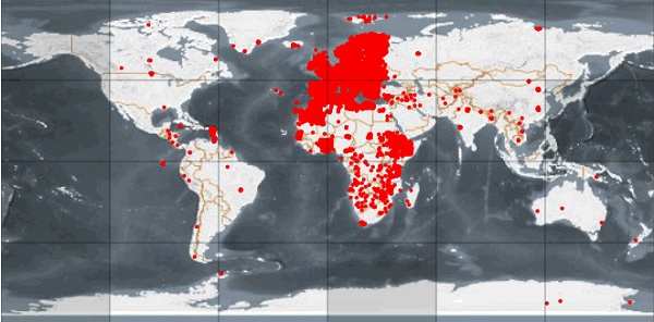
Spatial coverage: Check the spatial coverage of the collection on a map available on the Third Party Missions Dissemination Service.
Details
DATA SET SPECIFICATIONS
- European Space Agency, 2019, SPOT 4-5 Take 5 ESA archive. Version 1.0.https://doi.org/10.5270/esa-iboli84
PROCESSING LEVEL
APPLICABLE TERMS & CONDITIONS
DATA CITATION
RESOURCES


Take5 Product Format
Other

List of SPOT-4 and SPOT-5 selected sites
Other
SPOT Take5 CNES web site
Catalogue
SPOT Software Tools
Software Tools
Get Help?
ESA Earth Observation User Services Portal