- News
- Trailblazing ERS-2 mission ena...
Trailblazing ERS-2 mission enables climate change applications
07 Feb 2024
As ESA’s ERS-2 satellite approaches Earth’s atmosphere for reentry, it’s time to reflect on the mission’s great achievements in powering climate-related applications.
Developed by a consortium of European industries led by Dornier GmbH, ESA’s ERS-2 satellite completed its mission in September 2011, after 16 years of operation. At that time, ERS-2 was still functioning nominally, but to mitigate the proliferation of space debris it was decided to end operations and de-orbit the satellite.
The average altitude was lowered to 573 km where the satellite was passivated, meaning the remaining fuel was depleted, all instruments deactivated, and batteries discharged to reduce the risk of fragmentation during orbital decay.
ERS-2 disposal was conducted in line with the ESA space debris mitigation requirements applicable to new projects, demonstrating the Agency’s strong commitment to reducing space debris. Now it’s time for this pioneering satellite to reenter the atmosphere naturally and start to burn up.
More than ten years after ERS-2 ceased operation - together with its predecessor ERS-1 (1991-2000) - the ERS heritage datasets, curated and made accessible by ESA’s Heritage Space programme - still help investigate and address key climate-related challenges.
The climate crisis has increased the severity of serious weather events, such as flooding and ERS-2 was often used to monitor floods, in the context of the International Charter on Space and Major Disasters.
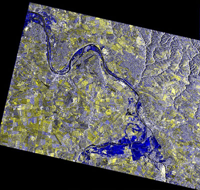
Archives of ERS-2 data still support change mapping, with pre-, cross-, and post-event Synthetic Aperture Radar (SAR) images of flooded areas providing insight into assessment of flood risks – vital information to prevent floods turning into major disasters [1].
The mission’s onboard C-band scatterometer, capable of robust measurements of ocean surface wind fields, also served to improve weather forecasting.
The ERS-2 satellite delivered a step change in the monitoring of ozone, thanks to its ground-breaking high precision instrument - the Global Ozone Monitoring Experiment (GOME). With measurements at higher spectral resolution and over a broader range of wavelengths than was previously possible, during its lifetime, GOME helped track the health and recovery of the Antarctic ozone hole.
Altimetry data track long-term ice loss
The radar altimeter onboard ERS-2 provided information on surface height of sea and ice surfaces, helping show trends and predict regional sea level rise related to climate warming.
Sea ice is a key piece of the climate jigsaw puzzle and scientists have recently leveraged ERS altimetry data to uncover long-term sea ice decline that are often masked by year-to-year variability.
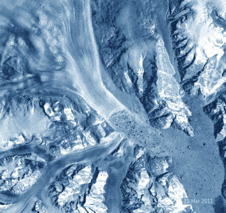
The new continuous dataset pioneered a combination of 29 years of ESA altimetry data from the ERS satellites, Envisat and CryoSat, to show that Arctic sea ice below the latitude of 81.5 degrees north is melting at a rate of approximately 13.1% per decade. Antarctic sea ice evolution displayed no significant trends along the whole period, but a drop in volume is observed after 2016.
Climate impacts ground subsidence
A forerunner in Synthetic Aperture Radar Interferometry (InSAR), the ERS-2 mission, together with its predecessor ERS-1, paved the way for multiple InSAR capable missions, such as Copernicus Sentinel-1, COSMO-SkyMed and TerraSAR-X/TanDEM-X.
InSAR is currently one of the most accurate methods to generate digital elevation models and help monitor ground displacements and subsidence on a large scale. As a tandem mission to ERS-1, ERS-2 enabled InSAR detection of small changes on Earth’s surface with a range precision of 1 cm [2].
An example of use of this technique is provided by an Italian national scale project implementing advanced persistent scatter interferometry to about 20,000 SAR images from 1992 to 2014, by the ERS, Envisat and COSMO-SkyMed satellites [3].
The extent of ground subsidence and its relation to climate change can only be monitored and determined through the availability of long time series of data provided by a combination of current and heritage missions, such as Copernicus Sentinels in combination with ERS and Envisat data.
The ERS-2 mission has provided invaluable long-term data on the impacts human activity has on our planet, providing striking information on flooding, sea level rise, ice loss and ground subsidence.
The data acquired by the mission also serve long-term global records of essential climate variables, helping scientists track changes associated with the climate change challenge.
Mirko Albani, ESA’s Head of the Heritage Space Programme, says, “The ERS-2 satellite has provided a stream of data, which has changed our view of the world in which we live. It has provided us with new insights on our planet, the chemistry of our atmosphere, the behaviour of our oceans, and the effects of humankind’s activity on our environment – creating new opportunities for scientific research and applications.”
References
- Romero et al. “ERS-1/2 and Sentinel-1 SAR Data Mining for Flood Hazard and Risk Assessment in Lima, Peru.” Appl. Sci. 2020, 10(18), 6598.
- R. Lanari et al. "ERS Differential SAR Interferometry: A powerful tool for surface deformation analysis.” 2008 IEEE Radar Conference, Rome, Italy, 2008, pp. 1-6.
- Costantini et al. (2017). “Analysis of surface deformations over the whole Italian territory by interferometric processing of ERS, Envisat and COSMO-SkyMed radar data.” Remote Sens. Environ. 202, 250–275.