- News
- Space data unearths small-scal...
Space data unearths small-scale mining in Burkina Faso
14 Feb 2023
Satellite data from ESA’s Pléiades Third Party Mission and Copernicus Sentinel-2 were used to demonstrate that deep learning models can accurately and inexpensively identify artisanal and small-scale mining, even in challenging semi-desertic environments.
“We hope our method will help to improve the management of these often-unregulated excavation practices, benefiting both the environment and the well-being of local communities,” says researcher Lorenzo Nava.
The research was conducted by scientists from the Department of Geosciences of the University of Padova, Italy, and the Centre Tecnològic de Telecomunicacions de Catalunya (CTTC) in Barcelona, Spain.
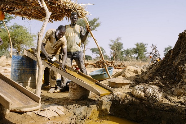
Artisanal and small-scale mining (ASM) provides a source of subsistence for many households in sub-Saharan Africa. Burkina Faso is currently the fastest-growing and fifth-largest gold producer in Africa, with ASM providing a livelihood for four to five million people. 75% of households in the country’s Bam province report that ASM is their primary source of income.
Unfortunately, ASM triggers major environmental, social, and health issues. Many mines exist in the informal mining sector and rely on an unskilled workforce using rudimentary tools and techniques. Issues include mercury and other contamination, unsafe working conditions, child labour, respiratory problems, and land-use conflicts.
Government institutions and legal mining companies need ASM inventories to efficiently plan and implement management strategies for their formalisation. In-situ datasets are scarce and in many regions dangerous to collect, due to the presence of armed groups. Instead, satellite data analysed by deep learning protocols prove to be the ideal method of mapping small mines.
Pléiades high resolution images are key
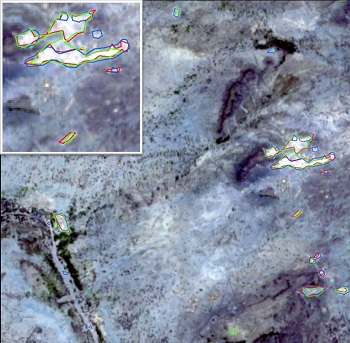
Copernicus Sentinel-2 Level-2A (bottom of atmosphere) multispectral imagery with a resolution of 10 metres were selected as easy-to-access large-scale data to analyse.
The optical tile selected by the authors is composed of 3710 × 3836 pixels, which correspond to 14,232 square kilometres, and four optical bands (blue, green, red and near-infrared).
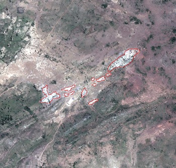
To check the performance of the deep learning model, mines needed to first be manually identified in the dataset based on differences in colour and texture over time. To this end, the researchers used imaging data from the Third Party Mission Pléiades satellite, which has a very high resolution of 0.5 metres.
“The spatial resolution of Pléiades imagery is such that it is possible to manually locate and delineate ASMs. On the other hand, with Copernicus Sentinel-2 data, this procedure is only feasible for the largest mining sites,” explains Nava.
ESA enables free access to Third Party Mission data like those of Pléiades for research and application purposes.
Automation with deep learning
While manual identification is possible, this is impractical for identifying mines on a large scale. A central aim of the research was to provide a generally applicable method for high-quality automated mapping.
One way to try to identify mines in satellite imagery is by classifying pixel-by-pixel, but treating each pixel separately neglects the geographical context and results in a speckled output.
In contrast, deep-learning methods, particularly convolutional neural networks, have shown promising results in a wide number of image processing applications, including image segmentation. The adapted ‘U-Net’ model architecture used by Nava et al. was originally designed for identifying skin lesions in images.
“U-Net has a simple structure, but it has demonstrated good performance in several segmentation tasks, and above all, it is able to output accurate segmentation results even with a small training dataset,” says Nava.
The colour and texture contrast between bare soil, muddy water and mines is typically small, making it much harder to identify mines in Burkina Faso’s semi-arid climate than in densely vegetated regions. The proposed automated mine identification method is reliable in these tough conditions, even using the low-resolution Copernicus Sentinel-2 data, ensuring that it is readily adaptable to other regions.
In the future, training the model on higher-resolution satellite imagery, like those of Pléiades, is expected to yield even better results.
Nava concludes, “Our approach is quite straightforward and easily reproducible. It can offer governments timely and precise knowledge about small-scale mining locations inside their territories, necessary for designing and implementing management strategies for ASM formalisation and policy enforcement, as well as to plan environmental remediation interventions.”
The identification of small mines in hard-to-reach areas is just one of the many applications of Earth observation satellite data made accessible by ESA.
Find out more about Pléiades data.
Reference
Nava, L., Cuevas, M., Meena, S.R., Catani, F., Monserrat, O. (2022). Artisanal and Small-Scale Mine Detection in Semi-Desertic Areas by Improved U-Net. IEEE Geoscience and Remote Sensing Letters, 19, 1–5. https://doi.org/10.1109/LGRS.2022.3220487.