- News
- Long-term satellite data show ...
Long-term satellite data show wind farms can affect local air currents
10 Nov 2022
Decades of satellite data have allowed for the first long-term study of the impact of offshore wind farms on downstream wind flow in coastal areas.
This will help scientists better understand how coastal wind farms impact power generation from wind energy facilities that lie in their wake. It can also help decision making on where to build future wind farms.
The research drew on wind speed measurements from ESA’s Envisat Heritage Mission, as well as Copernicus Sentinel-1.
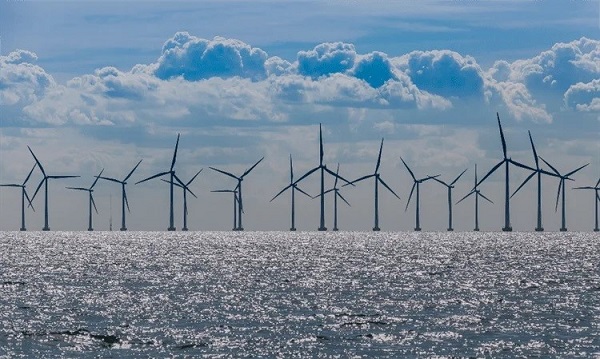
Wind turbine wakes are long horizontal streaks of reduced wind speeds and increased turbulence on the downstream side of offshore wind farms. They are difficult to quantify due to their variable nature and interactions with the turbulent atmospheric boundary layer.
Most offshore wind farms are built in coastal regions, where wind patterns are more variable and complex along the coast than they are further offshore.
Quantifying wakes is important, because offshore wind farms have the biggest growth potential of any renewable energy technology, and Europe plans to double the rate of such farm installations in the next five years [1]. This will bring offshore wind farms closer together.
Wind power density is proportional to the wind speed cubed, so any reduction in wind speed leads to a larger reduction in the power generation of downstream offshore wind farms.
Future offshore wind farms should be carefully spaced
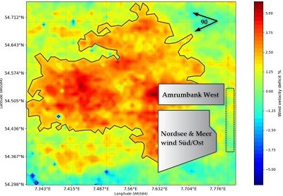
The study, led by scientists at the Technical University of Denmark at the Train2Wind project, funded by European Union Horizon 2020, found that offshore wind farms cause a 2-10% reduction in mean downstream wind speed at 10 m above mean sea level, with some wakes extending over 100 km [2].
The average wind wakes are 20-40 km in size, suggesting that future offshore wind farms should be built at least that distance from the nearest neighbouring wind farm site.
The wind speed reduction generated by such farm sites is proportional to their output power capacity. And the farm layout plays a role: since the effect of individual wind turbines are superimposed, the wind wakes follow the layout and configuration of the offshore wind farm.
The study also assessed the existing wind patterns of each site to subtract their effect once the wind farms were built. While you might expect that wind conditions upstream and downstream of a site are equivalent before commissioning, natural horizontal coastal wind speed gradients can lead to a change in onshore and offshore wind speed of the order of 4% at 10 m above mean sea level.
Long-term measurements allow before and after comparison
Data from the heritage Envisat satellite currently maintained accessible and continuously improved via ESA’s Heritage Space programme proved crucial for determining the influence of offshore wind farms on wind flow.
“The large archive of data let us understand the situation far offshore, for areas not covered by any other experimental method, and allowed us to compare the wind flow before and after the commissioning of off shore wind farms,” says lead researcher Abdalmenem Owda.
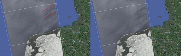
Synthetic aperture radar (SAR) data from Envisat, and from the later missions of Copernicus Sentinel-1A and -1B, were used to generate wind maps at 10 metres above mean sea level. Envisat was operational from 2002-2012, Sentinel-1A since 2014 and Sentinel-1B from 2016 until late 2021.
In the study, more than 8700 SAR scenes were used to determine the wind wakes of eight different wind farm sites, in the North Sea and Kattegat.
SAR measurements from satellites are currently the only type of data that can measure the size and behaviour of wind wakes, because the measurements span over large distances and long timescales while providing a high enough accuracy and spatial resolution.
TPM data will improve future research
Continuing Envisat’s legacy, modern satellite SAR data will provide an even higher spatial resolution. The researchers are planning to also use ESA’s Third Party Mission data from the TerraSAR-X and COSMO-SkyMed satellites, which can improve the spatial resolution from 10 metres down to one.
While the current study found wind speed reductions up to 10% at 10 m above mean sea level, wind turbine rotor hubs commonly lie at 80 m or even 100 m. One can imagine that wind speed deficits are even larger when you get closer to the rotor height. “At the rotor height, wind speed reductions are larger than 10 percent,” concludes Owda.
Additionally, better data analysis could improve the SAR wind retrieval accuracy, compensating for errors due to the backscattering from human-made objects at sea around offshore wind farms. The influence of ocean waves and seabed topography on SAR measurements can also be better explored.
Finally, the present data will be used to improve simulations of wind flow in and around offshore wind farms. These can support decision-making in where and how to construct future ones in Europe.
This is just one of the many ways in which ESA missions contribute to a green future for Europe, one of the key priorities presented in ESA’s Agenda 2025 and important for achieving the United Nations Sustainable Development Goals.
References
Sesto, E and Lipman NH. Wind energy in Europe. Wind Europe, Brussels Belgium. 2020. Available online: https://gwec.net/global-offshore-wind-report-2021/ (accessed on 8 March 2022).
Owda A and Badger M (2022). Wind speed variation mapped using SAR before and after commissioning offshore wind farms. Remote Sensing, 14, 1464, https://doi.org/10.3390/rs14061464.