- News
- How scientists use space data ...
How scientists use space data to help advance the energy transition
21 Feb 2023
Scientists are using remote sensing data disseminated by ESA to support the green transformation of the world's power generation infrastructure.
These data are also enabling research that could help to curb emissions from traditional energy sources.
As part of the revitalised global commitment to address the climate crisis, governments are stepping up their drive to ensure universal access to reliable, sustainable and secure energy.
The unprecedented insight into the planet delivered by Earth observation data is crucially important to these efforts.
ESA disseminates products from agency-led satellites, as well as commercially focused missions on a free basis for research purposes, enabling remote sensing scientists to investigate different aspects of energy production systems.
Supporting the green energy transition
Europe has bold plans to scale up renewable energy generation in the next decade and the expansion of the wind power industry is an important part of this ambition.
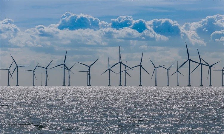
As part of a recent project, researchers drew on decades of satellite data to complete an analysis that could help decision-makers to choose locations for new offshore windfarms.
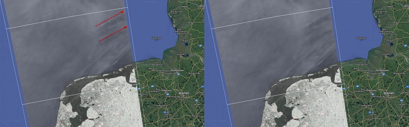
The scientists used SAR data from Envisat – which is an ESA Heritage Mission – and Copernicus Sentinel-1 to study the downstream wakes of wind turbines, which are typically characterised as long horizontal streaks of reduced windspeeds and increased turbulence.
When picking the site of a new windfarm, it is important to avoid areas impacted by these wakes to avoid any negative effects on power generation.
The study – in which 8700 SAR scenes were used to observe eight separate offshore sites – showed that turbine wakes extend for 20 to 40 km on average, suggesting that new windfarms should be built at least this distance from the nearest neighbouring windfarm on its downstream side.
The Envisat data used in the analysis are maintained, made accessible and continuously improved through ESA’s Heritage Space programme.
To build on the current project, the research team plans to use data from ESA’s Third Party Missions programme, which are available on a free basis for research purposes.
By using high-resolution observations from the German TerraSAR-X satellite and the Italian COSMO-SkyMed constellation, the researchers could deliver a more detailed analysis of the wakes created by coastal turbines.
Tracking methane plumes
Promoting the responsible management of key environmental resources – such as natural gas and oil – is another important energy objective.
Given the potency of methane as a planet-warming gas, reducing these emissions from oil and gas infrastructure could be key for climate change mitigation efforts.
However, despite the rapid development of space-borne methane detection methods over land, it remains difficult to use remote sensing missions to monitor these emissions over sea, as the wavelengths that are used to monitor methane are easily absorbed by water.
In recent research, scientists used data from the WorldView-3 satellite, which is part of ESA’s Third Party Missions programme to address this challenge. The project also drew on data from the US-led Landsat-8 mission.
WorldView-3 is owned and operated by US space technology firm Maxar. Its data have an impressive spatial resolution of 3.7 m and a high signal-to-noise ratio, which make it a powerful mission for methane mapping.
The mission also offers an imaging mode, which is suited to monitoring the gas over sea.
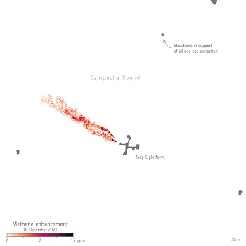
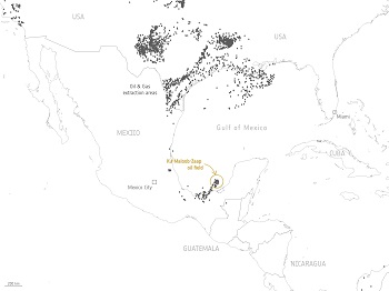
The study focused on oil and gas production activities off the coast of the Mexican state of Campeche, in one of the country’s major oil fields.
It revealed that a huge methane leak from one oil and gas facility resulted in the release of some 40,000 tons of methane into the atmosphere.
The presence of these plumes was verified through comparisons with imagery collected by other Earth observation missions, as well as other data sources.
The project demonstrates how satellite data can be used to produce actionable information about methane plumes from offshore infrastructure, which could help to inform strategies to reduce these emissions.
Another Third Party Mission that delivers high-resolution observations of methane and other planet-warming gases is the GHGSat constellation.
Research has demonstrated how GHGSat and Copernicus Sentinel-5P can work hand-in-hand to monitor methane emissions from industry.
Sentinel-5P maps atmospheric gases around the globe every 24 hours. Its TROPOMI spectrometer delivers data with a resolution as high as 7 km × 5.5 km for methane, but these data cannot be used to pinpoint specific point sources.
However, guided by maps from Sentinel-5P, GHGSat can use its more detailed observations to hone in on the sources of methane leaks and determine the specific industrial facilities responsible for them. Further data collections that are suitable for research into energy and natural resources are available online.
What is the green energy transition?
The international community is committed to both limiting global warming to below 2℃ by the end of the century and achieving carbon neutrality by 2050. Satellite data have played a key role in identifying the main cause of climate change as greenhouse gas emissions from burning fossil fuels, such as oil and gas. Consequently, shifting away from an energy mix grounded in fossil fuels to one that utilises renewable energy is crucial for global climate action. As part of this transition, new infrastructure is being developed based on solar, wind, hydroelectric and geothermal energy.
How can satellite data support cleaner energy generation?
As energy systems shift away from fossil fuels, satellites are making vital contributions to the development of renewable power infrastructure. Earth observation missions can help identify promising locations for new green energy facilities – such as solar plants or offshore windfarms – by delivering information on solar geometry and radiation, windspeeds and water flow.
In addition, satellite data are used to help the oil and gas industries monitor environmental impact and take action to reduce planet-warming emissions.