- News
Envisat delivers a decade of insights into ocean oil slicks
01 Mar 2023
More than ten years after it beamed its final image back to Earth, ESA’s Envisat satellite is still helping to investigate and address key societal and environmental challenges.
Using radar data from this ESA Heritage Mission, scientists have created a historical dataset detailing a decade of oil slicks in the Gulf of Guinea, a region of the Atlantic Ocean off the west coast of Africa.
This unprecedented analysis – which mapped some 18,000 human-induced and naturally occurring oil slicks between 2002 and 2012 – could help devise oil pollution mitigation strategies in the region, as well as providing methods to be applied in future-large scale detection studies.
Encompassing some 2.4 million square km of the tropical Atlantic Ocean, the Gulf of Guinea is particularly susceptible to incidences of human-induced oil pollution, because it hosts several busy shipping routes and a growing petroleum exploration industry.
In addition, the region’s unique geology means that crude oil naturally seeps from the seabed into the water through layers of sediment that line the ocean floor.
ESA’s Envisat mission – which was operational for 10 years after its launch in 2002 – hosted an Advanced Synthetic Aperture Radar (ASAR) instrument that was adept at monitoring oil floating on the water’s surface.
Data from ASAR – which was one of 10 sensors hosted by the mission – are maintained, disseminated on a free basis, and continuously improved through ESA’s Heritage Space Programme. More information on freely available Envisat data collections and how to access them can be found online.
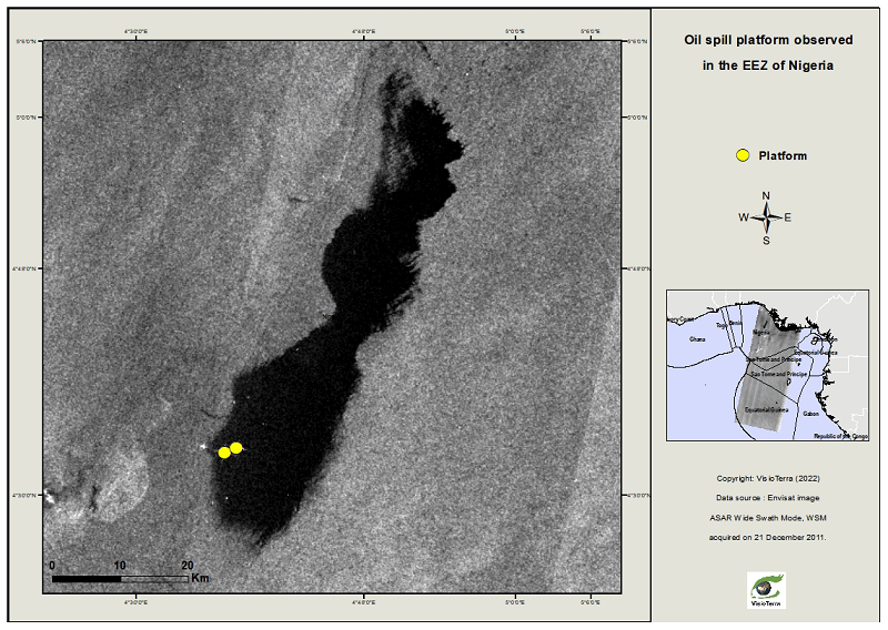
In radar images, areas of sea covered by oil appear as smooth dark regions with low backscattering, when compared to the surrounding ocean. This effect is caused by the dampening effect that oil has on radio waves.
As part of the analysis – which was published in the journal Earth System Science Data – the researchers pre-processed 3644 Envisat radar images by radiometrically correcting the data and matching these acquisitions with known coordinates.
They then used an established manual detection approach for identification of oil slicks, which consists of image interpretation based on morphological criteria, contrasting images collected at different timepoints, and validation of findings using external data sources.
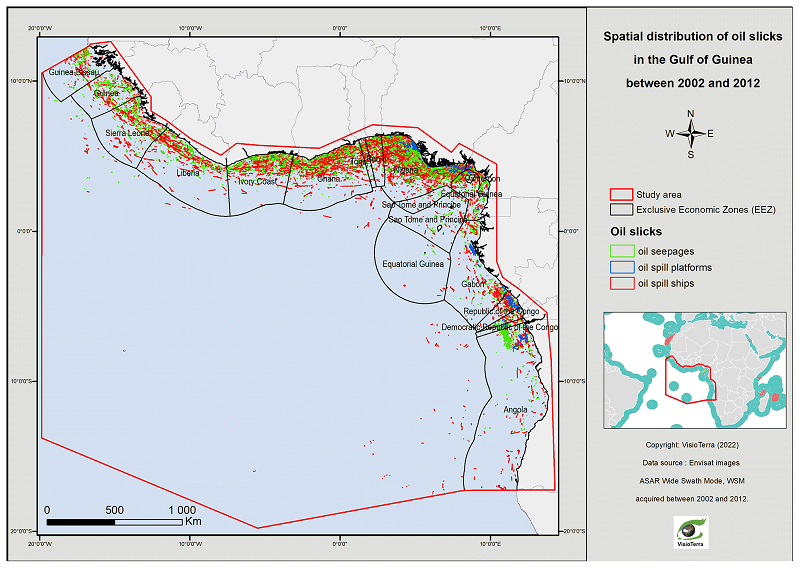
This method enabled the team to distinguish between human-induced oil pollution and slicks that resulted from natural seepage of hydrocarbons through the seabed.
In addition, the location and nature of confirmed anthropogenic oil slicks helped identify their source; for instance, spills from oil infrastructure are located close to platforms and typically have an irregular geometric shape, whereas spills from ships are linear in form and lie in the vessel’s wake.
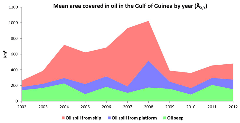
It was reported that, between 2002 and 2012, the total area covered by oil slicks was 547 square km, consisting of 145 square km of natural oil seepage, 111 square km of oil spills from platforms, and 308 square km of oil pollution from ships.
Natural oil seepage was observed across the Gulf of Guinea and the area covered by these slicks remained relatively constant during the study period.
Oil pollution from ships was present along most major shipping routes, with spills from oil platforms concentrated along the coasts of oil-producing countries like Nigeria, the Republic of the Congo, Angola, and Ghana.
A decrease in the area of ocean covered by human-induced oil spills was observed between 2008 and 2009, which was likely an artifact of the post-2008 global economic shut down.
Zhour Najoui, remote sensing scientist at VisioTerra in France and lead author of the study, said: “In this research, we used ESA Heritage data to complete an analysis that supports a key United Nations Sustainable Development Goal that focuses on conserving the oceans and marine resources for sustainable development.
“The pollution statistics from the research will make it possible to propose a monitoring and management plan for the area studied. In addition, the methods we describe could be applied to future oil pollution tracking projects that draw on data from current, high-resolution radar missions, such as Copernicus Sentinel-1.”
References
Najoui, Z., Amoussou, N., Riazanoff, S., Aurel, G., and Frappart, F.: Oil slicks in the Gulf of Guinea – 10 years of Envisat Advanced Synthetic Aperture Radar observations, Earth Syst. Sci. Data, 14, 4569–4588, https://doi.org/10.5194/essd-14-4569-2022, 2022.