 Floods Overview
While the damage caused by many forms of disasters are commonly immediate, floods are often longer events; due to the sheer amount of water left behind in their wake. Commonly caused by flash floods and torrential rain, inhabited areas near rivers and bodies of water are most susceptible to floods. Particularly strong floods can sweep away buildings, and property damage and crop destruction are the most common after-effects. The flood waters can also become contaminated and cause illness or disease. Satellite data can prove very useful in the analysis and monitoring of flood events. It can be used to provide historical reference of the area before the flood, as well as determining the extent and location of flood waters after the flood, aiding in the relief and recovery efforts.
Latest Events
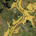
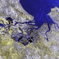
Flooding in Brazil - June-July 201411 July 2014 - These Landsat 8 images, acquired 05 July 2014, show a large area of flooding near Sao Borja city, in Rio Grande do Sul, Brazil. The southern Brazilian state has been affected by floods since late June 2014, which forced 6,000 people to evacuate. 
Flood - Thailand, October 2011The 2011 monsoon season caused flooding in Thailand that lasted from July 2011 to January 2012 following Tropical Storm Nock-ten. 815 people died in the disaster and over 13 million were affected. The flooding affected almost the entirety of Thailand to some degree.
Floods
|
Related Links
|
||||||||||||||||||||||||||||||||||||||||||||||||||||