 Historical Views
Our world is constantly changing around us, and the full scope of these changes can often be missed as we grow accustomed to these developments. Satellite data can be used to capture views of important monuments and help plan and chart the progress of construction projects. The Historical Views section looks at such landmarks and how they may have changed over time. See also the Envisat Galleries, which feature some of the more impressive miscellaneous images captured by the satellite during its operational lifetime.
Latest Historical Views
Results: 36
Karachi, Pakistan13 September 2018 - This weeks Earth Watching comparison shows the city of Karachi, Pakistan and its Arabian Sea coastline. Landsat 5 and 8 imagery have been used to highlight the changes in urbanisation during the last 29 years. 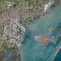
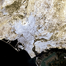
Venice, Italy21 December 2017 - This Sentinel image comparison features Venice, the famous "City of Bridges" in Italy. The comparison uses Sentinel-1 and -2 images to highlight the different applications the Copernicus Sentinels provide for urban monitoring. 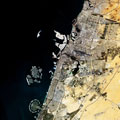
Dubai, United Arab Emirates17 February 2017 - Sentinel-1 and 2 were used to produce this image comparison of Dubai, as seen in 2016. The images demonstrate what these Radar and Optical satellites of the Copernicus family can achieve. 
Stromboli Volcano21 August 2014 - Stromboli Volcano, in Italy, which has been undergoing eruptions in August 2014, can be seen in these Landsat 8 images. The flows of lava erupting from the volcano are visible in images acquired both at night and during the day. 
Seine Bay, Normandy - 70 years after D-Day19 June 2014 - This Landsat 8 image, acquired in 2013, shows the Seine Bay, where 70 years ago the D-Day invasion on the coast of Normandy began. It was one of the most significant points in the Second World War and is remembered every year on 06 June. 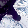
Svalbard, Norway08 May 2014 - The Svalbard archipelago, in Norway, can be seen in this Landsat 8 image, acquired 03 May 2014. Svalbard is the northernmost permanently inhabited location in the world. 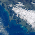
Tuscan ArchipelagoThis image, acquired in the month of January 2014 by the Landsat 8 satellite, shows the Tuscan Archipelago off the west coast of Italy. 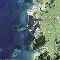
Saemangeum Dam - South KoreaThis series of images from the ERS-1/2, Envisat and Landsat satellites features Saemangeum Dam on the coast of the Yellow Sea in South Korea. The images follow the development of the area from 1987 to 2013. 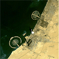
Dubai grows on the seaDubai is a city in the United Arab Emirates, located within the emirate. The emirate of Dubai is located on the southeast coast of the Persian Gulf and is one of the seven emirates that make up the country. It has the largest population in the UAE (2,106,177) and the second-largest land territory by area (4,114 km2) after Abu Dhabi, the national capital. 
Kansai and Kobe International Airport (Osaka Bay, Japan)Kansai International Airport is located on an artificial island in the middle of Osaka Bay, 38 km southwest of Osaka Station, located within three municipalities, including Izumisano (north), Sennan (south) and Tajiri (central) in Osaka Prefecture, Japan. |
||